State Symbols of Jharkhand
Last updated on April 18th, 2024 by Editorial Staff
By Naeem Noor | Updated on April 18, 2024
Reviewed by Rittika
Jharkhand is located in the northeast part of India. In the year 2000, the southern part of Bihar was divided into Jharkhand, one of India’s newest states. It is the 14th most populous state and the 15th largest by area. Jharkhand is bordered on the north by Bihar, on the east by West Bengal, on the south by Odisha, on the west by Chhattisgarh, and on the northwest by Uttar Pradesh. Ranchi is the state capital.
In Jharkhand, there are a total of 32 rivers. The Subarnarekha River (also known as the Swarnarekha River) flows through Jharkhand, West Bengal, and Odisha in India.
Hemant Soren (JMM) is the current Chief Minister of Jharkhand, while Ramesh Bais is the current Governor. Jharkhand’s official language is Hindi, which is spoken by the majority of the state’s residents, though other regions speak their own languages. Nagpuri, Khortha, Kurmali, Magahi, and Bhojpuri are among them.
Demographical Profile
Jharkhand covers a total area of 79,716 km2 and has a population of about 32,988,134 people. The literacy rate is 67.6%, with a sex ratio of 948 females per 1000 males.
Climate
In Jharkhand, there are three distinct seasons, November to February, the cold-weather season is the most enjoyable time of the year. In December, high temperatures in Ranchi range from around 50 degrees Fahrenheit (10 degrees Celsius) to the low 70s Fahrenheit (low 20s Celsius) on a regular basis. From March through mid-June, the hot-weather season is in full swing. May is the hottest month with the highest temperature of 90s F (approximately 37 °C) and lowest temperatures of mid-70s F. From mid-June to October, the southwest monsoon produces virtually all of the state’s annual rainfall, which ranges from about 1,000 mm in the west-central region to more than 1,500 mm in the southwest.
Wildlife and Natural Vegetation
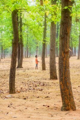
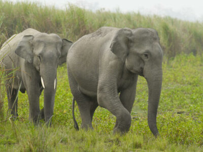
The diverse flora and wildlife have given Jharkhand the title of the “Land of Forests”. Forests cover more than a quarter of Jharkhand’s land area. The Chota Nagpur plateau has the majority of the forests; those in the plains have largely been destroyed to allow for agricultural cultivation. Sal (Shorea robusta), a valuable hardwood is abundant in Chota Nagpur and the natural vegetation is deciduous forest. Other trees include the Asan (Terminalia tomentosa), whose leaves are used to feed silkworms in the sericulture industry, as well as a number of trees, utilized in the lac production process (a resinous substance used to make varnishes). Mahua (Madhuca longifolia) is a local tree that produces pleasant edible blooms that are used to manufacture liquor. Raw resources for paper production come from Chota Nagpur, where bamboo and bhabar (an Indian fiber grass; Ischaemum angustifolium) are grown. The banyan (Ficus benghalensis), the Bo tree (Ficus religiosa), and the Palmyra palm are among the other prevalent trees found on the plain (Borassus flabellifer). The Bengal tigers of the Hazaribag Wildlife Sanctuary are well-known. Only the most distant jungles are home to these endangered species, which live alongside leopards, elephants, and bears. Throughout the state, there are numerous species of small mammals, birds, reptiles, and fish.
The state animal is the Indian elephant, and the state bird is the Koel.
Economy
Jharkhand has abundant surface and groundwater, as well as fertile soil and a temperate climate, all of which have contributed to the state’s strong agriculture sector. Hazaribagh and Dhanbad have a lot of sandy soil. In the Rajmahal area, black soil can be found. Laterite soil can be found in Ranchi’s western section, Palamu, and parts of Santhal Parganas and Singhbhum.
Raising cattle for meat, dairy products, and wool has been highlighted in the state’s agricultural development projects. A selective sheep-breeding program was undertaken in the town of Chatra, in the northwest, and wool-collection centers were built in the district of East Singhbhum, in an effort to improve quality and boost the output of mutton and wool. The majority of the state’s goats are raised in the northeastern districts of Dumka, Deoghar, and Godda, while goat farms may also be found in the districts of Sahibganj, Chatra, and Ranchi.
Culture (Art, Music, and Cuisines)
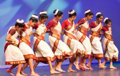
Many of the tribal peoples’ settlements have some qualities in common. During festive times, most villages have a collective dance floor that comes alive. Chhau, an intricate masked dance of the southeastern region, particularly the Saraikela and East Singhbhum districts, is one of Jharkhand’s most well-known dances.
Arsa, Dhuska, Chhilka are some local cuisines. Locals people are experts in crafts using bamboo and wood for basket preparations, hunting and fishing tools, and rice huskers. A wild grass called Sabai is dyed and braided into bowls, penstacks, coasters, mats, colorful boxes, dolls, and other items. In addition, a range of handiworks with tribal motifs, such as wood inlay boxes, combs, carved door panels, bowl-shaped umbrellas, tribal theme toys, and carvings, as well as old ‘bird-woman’ figures, are available in the local bazaars.
Panchi and Parhan are traditional Jharkhand women’s dresses. The lower garment is called panchi, and the upper garment is called parhan. Jharkhand, often known as Vanachal (the Land of Woods), is a well-cultured state with a vibrant textile and fabric legacy.
Tourism
The state of Jharkhand is noted for its waterfalls, hills, and sacred sites. Major religious sites include Parasnath, Baidyanath Dham, Rajrappa, Jagannath Temple, and Dewri Temple. Latehar’s Tattapani Hot Water Spring The hot spring water emerges from many locations along the Sukari River’s bed. The hot spring, which is rich in sulfur, is thought to offer therapeutic and skin-beneficial effects.
For Hindus, Buddhists, and Jains, Itkhori is a sacred site. Panchghagh Falls Jonha Falls, Hundru Falls, and Dassam Falls are among the state’s many waterfalls. The state’s hill station is Netarhat. In Jharkhand, there are various wildlife sanctuaries that are popular with tourists, including Betla National Park and Dalma Wildlife Sanctuary.
State Information
| Official Language | Hindi |
| State Rank | 15 |
| Demonym(s) | Jharkhandi |
| Nickname | Pittsburgh of India |
| ISO | IN-JH |
| Formation Date | 15 November 2000 |
| Coordinates | Lat: 23.6102° N, Long: 85.2799° E |
| Area |
State seal

Motto of Jharkhand
Satyameva Jayate-"Truth alone triumphs"
State symbols of Jharkhand 👇
-
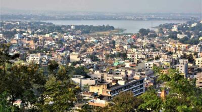
 State capitalRanchi
 -
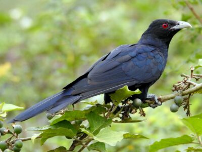
State birdKoel
-
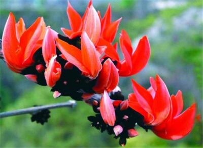
State flowerPalash
-
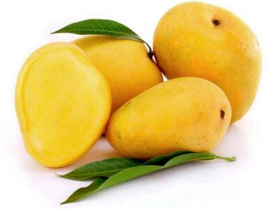
State fruitMango
-
State treeSal
-
State danceJhumair
-
State animalIndian elephant
-
State dishPitha

State location
Guess the Flags Quiz


Sharing is caring 🤗
State Flag of Jharkhand